The Headwind

April in central Illinois is a bitch. Other months are windy, but April is always the worst. This makes for some challenging bike rides.

Clearly it’s very nice when you have a tailwind, but you can’t do an entire ride with the wind at your back if you have any intention of ending up back where you started. The strong crosswinds are just downright dangerous in that there are times that you really think you’re going to be blown right over. You really want to minimize the amount of time you’re in a crosswind like this.

Then there’s the headwind. Oh, the headwind. It’s demoralizing to see a group of 20 strong bicyclists struggling to maintain 13 mph riding directly into a 25 mph (gusting to 40 mph) headwind. Sadly, this has been the situation on the last 10 or so long rides I’ve done this April.

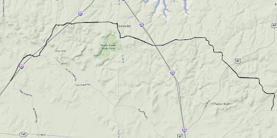
And then there was this weekend. Somehow I (along with two others) showed up at the wrong time for the Saturday ride, so the three of us headed out to Monitcello (50 mile round trip) straight into a powerful west wind. The first few miles seemed to go on for an eternity.

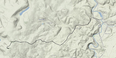
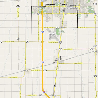
Monticello Ride Map

On Sunday the situation was slightly better in that there were four of us total, but it was slightly worse in that two of those riders were really fast and made the ride even more difficult. I’m not sure how much more I can take.

On the bright side I set a new speed record two weeks ago on the way back from Pesotum when I hit 39.8 mph on flat land. I’ve definitely ridden faster down steep hills, but never on the flat. Amazingly, the guy I was riding with at the time was going over 40 mph and he pulled away from me. Speed records aside, I’m ready for April to end.

The Highest Point in Maryland

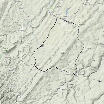
On my way back from Washington D.C. last weekend I took the opportunity to knock another state off my list of high-points-to-which-I’ve-bicycled. The previous Friday it was Pennsylvania. Monday it was Maryland’s turn. Backbone Mountain, the state’s high point, is nestled in the far western corner of the state, within walking distance from West Virginia.

I spent a good deal of time studying the area with Google Earth on Sunday night in my hotel room. Oakland, Maryland was the clear choice for my starting point. This was only 25 minutes off I-68. The actual peak is not accessible by any road, so I made due with the highest point on the closest road to the peak (U.S. 50), which was conveniently labelled as the Highest Point on the Maryland State Roads System. Perfect.

I had a little bit more time for this ride than I did a few days prior in Pennsylvania, so I decided to do a slightly longer ride and make it a loop instead of simply turning around once I reached the top. Since I would be riding down the other side of the mountain, this meant that I would actually have to ride back over the mountain a second time on a different road in order to return to my starting point. The temperature was a chilly 39˚ when I started, so I bundled up.

Backbone Mountain ride map

The unfamiliar roads and dense fog made for some interesting navigation challenges. Like Pennsylvania, there were many rolling hills as I started the loop on U.S. 219. Soon after I turned onto U.S. 50 the road turned upward. The climb itself was shorter than Mt. Davis was a few days prior, but it was much steeper. I spent some quality time in my lowest gear moving along at what seemed like a snail’s pace, but I made it. Six states down (TN, NC, KY, HI, PA, MD), 44 to go.

Rob at the top of Backbone Mountain

Plaque at the top of Backbone Mountain on U.S. 50

I descended the mountain, turned a corner, then started going back up it again, only this time I was on a different road. The second climb seemed roughly the same length and steepness as the first, though it was even foggier. Again I spent much time in my lowest gear. From the top I coasted most of the rest of the way back to Oakland.

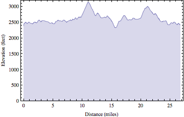
Backbone Mountain ride elevation profile

Once back in town I picked up a 12″ veggie sub on wheat bread with pepper jack cheese, lettuce, onions, tomatoes, pickles, green peppers, & black pepper from Subway. Unfortunately, I didn’t realize until I was driving out of town that the “lemonade” was actually some kind of disgusting carbonated junk instead. I think they must have had some hoses crossed in the fountain machine.

It was a nine hour drive back to Urbana from there. Interestingly, an hour or so later the temperature in West Virginia was around 70˚ and I was actually hot for most of the rest of the trip.

High Point Ride Information
Date: 2008-04-07 9:52 AM EDT
State: Maryland
High Point: Backbone Mountain
Elevation: 3095 feet
Climb Distance: 1.14 miles
Climb Ascent: 469 feet
Climb Average Grade: 7.8%
Climb Maximum Grade: 12%
Ride Distance: 26.8 miles
Ride Total Ascent: 2656 feet
Ride Maximum Speed: 38 miles/hour
Ride Start: Oakland, MD (2372 feet)
Ride End: Oakland, MD (2372 feet)

The Highest Point in Pennsylvania

It’s not widely known outside of this household that I have a goal to bicycle to the highest point in all 50 states. Well, at least the highest point that is accessible via bicycle, generally on a paved road. It is a lofty goal indeed, but I’m not super strict about the rules… and I’m not in any huge hurry. I just like riding.

As of last week I had 4 states down, including some big ones (Tennessee, North Carolina, Kentucky, & Hawaii). When I was planning my trip to Washington D.C. this past weekend I took a quick glance at some web sites and saw that Pennsylvania & Maryland had high points that were not very far out of my way (additionally West Virginia, Ohio, & Indiana, but I thought two would suffice for a single weekend). So I took my bike and thought if I had time I would ride them, if not no big deal.

The route from Meyersdale to the summit of Mt. Davis

I drove for nine or so hours by the time I reached Meyersdale, PA, at the foot of Mt. Davis. The weather was nice, and I was sick of driving, so I rode. As I was coming into town I noticed there were many wind generators perched atop the rolling hills. As soon as I stepped out of the car I realized why. It was windy. Really windy. And unfortunately, it was going to be a headwind the entire way up Mt. Davis.

Wind generators near Meyersdale, PA

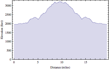
The elevation of Meyersdale was 1935 ft. and the summit of Mt. Davis is 3213-ish ft. So it was a decent change in elevation, but it was no Mauna Kea. As I began the 10 mile ride to the summit I quickly realized this climb was going to be a little different than many of the previous mountains I have ridden. It was really just one large rolling hill after another. It wasn’t very steep (the average grade was 3.2%, with one short 13% section). There were no switchbacks. The strong headwind made it tough, and I didn’t have the best legs after nine hours of driving, so it was slow going.

A sign directing visitors to Mt. Davis with rolling hills in the background

I rode through lots of farmland and passed many people I assume were Amish. There were several horse drawn buggies and a few diesel powered tractors (diesel is apparently okay for the Amish). Everyone waved and seemed rather friendly.

Towards the top the landscape finally turned from large rolling hills into a real actual climb. It got a little steeper at this point, but it was still managable. There was a picnic area at the summit, a sign indicating the significance of the location, and a short distance away was an observation tower. The wind made walking up the tower stairs an interesting experience, but I survived.

Rob at the summit of Mt. Davis, PA

View of Meyersdale, PA from observation tower at summit of Mt. Davis

Mt. Davis ride elevation profile

The long, straight roads and strong tailwind allowed for some fast descending. At one point I passed a group of Amish children who all waved to me as I sped past at 35 mph. When I returned to Meyersdale, I packed up my bike, got back in the car, and drove the remaining three hours to D.C. It was a good way to break up the monotony of driving such a long distance in one day.

High Point Ride Information
Date: 2008-04-04 3:19 PM EDT
State: Pennsylvania
High Point: Mt. Davis
Elevation: 3213 feet
Climb Distance: 3.5 miles
Climb Ascent: 1010 feet
Climb Average Grade: 5.4%
Climb Maximum Grade: 13%
Ride Distance: 19.4 miles
Ride Total Ascent: 1973 feet
Ride Maximum Speed: 45.7 miles/hour
Ride Start: Meyersdale, PA (1935 feet)
Ride End: Meyersdale, PA (1935 feet)

The Cobbles

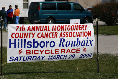
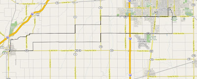
Saturday was my first bike race of the season. Melissa (the photographer) & I woke up early and drove down to Hillsboro, IL for the 2008 edition of the Hillsboro Roubaix bicycle race. The race actually has nothing to do with Roubaix, France. The name is just a play on the famous bike race Paris-Roubaix. Paris-Roubaix is known for horrible weather, poor roads, and, most of all, many sections of cobble-stones. In the spirit of the spring classics like Paris-Roubiax, the Hillsboro race threw in a half mile section of brick roads for every 22 mile lap.
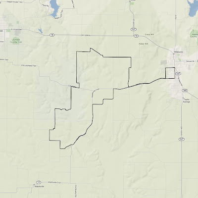
Hillsboro Roubaix course map

Many members of my Wild Card Cycling team took part in this race. We had a particularly large group in the Category 5 (beginner) race, including me. Amateur bike racing events are generally split up into several different, non-competing, races. Much like running races and triathlons have age group competitions, bike races are split up by category, which is generally determined by the ability and experience of a rider.

Team Wild Card had six riders in the Cat 5 race, out of a field of 50 participants. Our six riders are pretty good, each of us simply lacks race experience. The Cat 5 race was only one lap–22 miles. This is pretty short for a bike race, so chances were good it would hard racing from the get-go. Knowing this, Larry (one of the most experienced racers on the team) came up with a team strategy for those of us in the Cat 5 race.
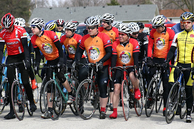
Mark, Tom, Dan, Stew, Karl, & Rob at the starting line
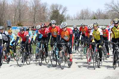
and they’re off

As soon as the race started there was a long downhill section followed by a steep uphill. Dan (who has a tendency to go downhill faster than most) moved to the front of the group and really hammered down the hill. This strung the pack into one long thin line. It was to be my job to push the pace on the uphill section, but I was badly positioned. I was a little too far back after the downhill section, so Karl hit the front and kept the pace high up the hill. By the time we made a right turn at the top of the hill (less than two miles into the race) we had already cut the size of the field in half.
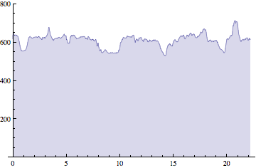
Hillsboro Roubaix course elevation profile

The pace remained high for the next few miles. At this point we hit another steep uphill section when something unfortunate happened. A car came from the opposite direction. This didn’t endanger the safety of any of the riders. We all knew the roads were open to traffic and we all stayed safely on the right side of the road. The sight of the car did cause a few riders to panic. A lot of people had to slow down, and a couple of people swerved off into the grass. Again, everyone was safe, but this had consequences for the race. Due to all the commotion a gap opened up right in the middle of the remainder of the group. I was at the very front of the second half. I pushed the rest of the way up the hill and I chased the leaders for about a mile all by myself in order to catch up. Once I caught the leaders again I was able to slow down rest a little bit.

It was now only six miles into the race and we had a lead group of 13 riders, four of which (Tom, Mark, Stew, & me) were Wild Card people. Not bad. There wasn’t much action for the next 14 miles or so. I stayed near the back most of the time. I tried on several occasions to move up through the pack, as I was willing to work harder at the front, but nobody really wanted to yield their position. So I basically rested for the majority of the race, my heart rate often in the 120’s. As we came back into town we had two large uphill sections, followed by a long, fast downhill, a half mile of brick roads, then a mad dash to the finish. It was time to move on to phase two of the pre-race plan.
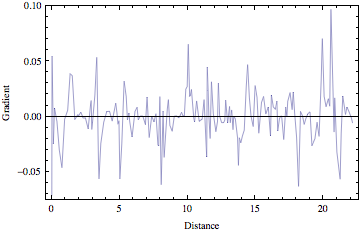
Hillsboro Roubaix course elevation gradient

On the first uphill section into town everyone stayed together. By this point we were starting to pass riders who had been dropped from other races that started before ours. Our pace car got stuck behind one of these riders and we got stuck behind the pace car (which we weren’t allowed to pass). So we moseyed up the hill.
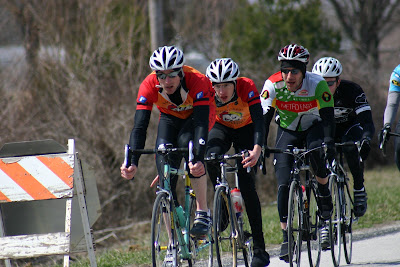
Stew & Tom drop the hammer

The road leveled, we passed the slower riders, then we hit the second hill. This is where Stew attacked. He was our strongest rider in the race and he hadn’t been working very hard up until this point, so he was good and strong. Then disaster almost struck. The pace car got stuck behind another slow rider, and Stew got stuck behind the pace car, AGAIN! Fortunately, this was near the top of the hill and Stew still had a lead over the rest of the group when he was finally able to move forward. Crisis averted.
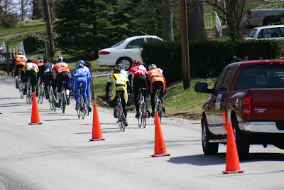
Team Wild Card took the bull by the horns on the last uphill

The group shattered going up the hill. Stew was out front. There was a chase group of four riders, including Tom. I had moved up from the back of the group and I was just behind the chase group with Mark and one or two others. We made a sharp left-hander then headed down the hill. The high speeds down the hill spread the group out even further. I looked up the road and saw Stew still had a pretty good lead with Tom nicely positioned in the second group. At the bottom of the hill we hit the brick road at around 35 mph. I was with one other rider at this point. We turned another corner, headed uphill, and I pulled away from him.

Every part of my bike rattled as the bricks attempted to tear it apart. At some point I heard a loud popping sound and almost immediately my back wheel started wiggling all over the place. I thought to myself, “Oh shit. I just got a flat tire a half mile from the finish.” I looked down and my tire still held air. I didn’t know what was going on, so I just kept peddling. As the brick road continued my rear wheel was still moving all over. I looked down at it three or four more times and it still had air each time.

The brick road ended and I turned the last corner with just a couple hundred meters remaining. I saw Stew had just crossed the line in first. The chase group of four people were sprinting to the line and I saw Tom win that sprint for second place. Next I finished sixth, then Mark came in behind me for seventh. Four places in the top seven was as good as we could have possibly hoped. A few minutes later Karl finished in 23rd, then after him Dan finished in 32nd. These two made big sacrifices to help their teammates then rode much of the race alone. It was really quite amazing.

On top of the tremendous success of team Wild Card in the Cat 5 men’s race, the next race to finish was the Cat 4 women’s race, where Wild Card member Severine won the sprint for first place.
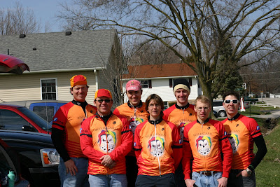
Dan, Karl, Rob, Severine, Stew, Tom, Mark (photo by Luke)

I didn’t see much of the action in the other races, but Larry finished fourth in the Masters 50+ race, but was possibly later disqualified for some reason. Luke, who was sick all week, DNF’d (did not finish) in the Cat 3 race. There were a few other people from Champaign-Urbana there, but I don’t really know how their races went.

Team Wild Card’s first event turned out to be pretty successful. Hopefully, this is a sign of things to come.
The Camp, Sunday

Sunday was a still a little chilly, but it was sunny and dry so I didn’t care. The plan for the morning was to ride to Makanda, a little town near Giant City park, to do repeats up and down a big hill that heads out of town. My legs were trashed from the previous two days, but given that we were planning to just ride back and forth on one section of the road it didn’t really matter if we stayed together. Everyone could ride their own pace.

We started out with a warm up ride over to Little Grassy Lake (my friend Cara’s favorite place). Then we headed back to Makanda where we met up with the riders who were staying at Lick Creek and we gathered for a team photo.

Wild Card Cycling team (photo courtesy of Karl)

Then came the hill. It was steep, but after the first repeat I actually began to feel better than before. After the second repeat I felt even better still. I was beginning to feel like Rob again for the first time all weekend. Our noon check out time was quickly approaching, so I was only able to do one more repeat. I really put a lot into the last climb. Phew. I hit my weekend high of 39.1 miles/hour on the way down. Not bad considering the road wasn’t very straight, but still room for improvement. My fastest ever was 46 miles/hour on the descent of Clingman’s Dome.

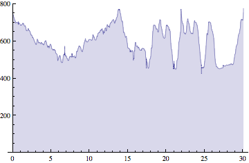
Distance: 30.06 miles
Duration: 1:55:00
Avg Heart Rate: 125
Max Heart Rate: 171
Calories: 1472
Total Ascent: 1262 feet
Weather: 48˚, sunny

Sunday’s route

Sunday’s elevation

After an easy ride back to the cabins we showered, packed up, and headed out. John A., Jay, and I had an excellent lunch at Moe’s Southwest Grill in Carbondale. I had both the burrito meal and the quesadilla meal. I was sleepy on the way home but I managed to stay awake somehow. Melissa came out to the street to greet me when I returned home. Perhaps she missed me a little.

Don’t have an emergency at the I-57 rest area just north of Effingham

The Camp, Saturday

Saturday was to be the big day of the camp. We planned to do 100 miles from Lick Creek to Golconda and back. Unfortunately, the weather was not cooperative. It was rainy and much colder (low 40s) than the day before. We delayed the ride, hoping the weather would improve, but after 30 impatient minutes we finally departed with no change in weather.

I was standing around talking to Jay, who was putting his shoes on, when the group decided to pull out. To our surprise they took off anyway. I waited a minute or so for him to get ready, but by this time the group was well up the road. We chased hard for about 4 miles to catch the group. It was right then we hit the first big hill of the day. My legs were really feeling the previous day’s effort as I slowly made my way up the hill. We stopped to regroup at the top. I was already tired from Friday, I was tired from chasing, I was tired from the first big ass hill. This is not how I wanted to feel 5 miles into a 100 miler.

At this point we all agreed to keep the pace sane and stick together for the first 30 miles, at which point we would reassess the situation. This plan lasted all of 30 seconds. The group spread out again on the rolling hills, and the riders up front were not keen on waiting. I spent the next 15 miles yo-yoing off the back of the group, desperately trying to cling on. I was soaking wet at this point and the brutal North wind chilled me to the bone. We stopped after 20 miles and I knew something had to change. There was no way I could come anywhere close to doing 100 miles at this pace on this terrain in these conditions.

We decided to split up. Six of us would continue another five miles before turning around for a 50 mile ride. Others would continue another 10 miles before turning around for a 60 mile ride. The ride back to lick creek was a bit of a blur. The weather was so nasty and I all I wanted was to be warm and dry. I was not the worst off though, as Ethan was a little underdressed and was shaking and chattering his teeth.

Five miles from the finish Jeff got a flat tire. We stuck around and helped him change it, then headed towards the finish. 300 meters later his tire went flat again. This was at the top of the big hill I mentioned previously and he and I were at the back of the group. Nobody else noticed he had flatted and they continued on their merry way. So Jeff & I stopped to fix his tire. He didn’t have a second spare with him so I gave him mine… except it didn’t fit. Jeff’s wheels have deep (aerodynamic) rims and the valve stem on my spare tire wasn’t long enough to go all the way through. Crap. I called Karl to see if they had returned to Lick Creek yet, but he did not answer. So I left Jeff to go get somebody’s car at the finish. I ran into Karl just past the bottom of the hill. He was waiting to make sure we knew which way to turn. We finished the last four miles together. Then I got into Jeff’s room, found his keys, and drove his truck back to pick him up. Incidentally, this won me the Best Team Support award at our dinner Saturday night.

A Wild Card Cycling mug I won at dinner on Saturday

Since we finished at Lick Creek I didn’t have any clothes or much food with me, and I didn’t have the keys to the car I rode in anyway. Karl was kind enough to offer to let me shower in his room and he lent me a sweatshirt and some jeans to wear. I almost didn’t take him up on the offer because I thought the lead group was only going 10 miles farther so they should have been back any time. I’m very glad I did take him up on the offer because the lead group decided to do the full 100, and they were gone for several more hours.

What an awful day.

Distance: 51.39 miles
Duration: 3:05:15
Avg Heart Rate: 142
Max Heart Rate: 179
Calories: 2819
Total Ascent: 1154 feet
Weather: 44˚, rainy

Saturday’s route

Saturday’s elevation

After the ride we headed back to Giant City, caught some Start Trek on TV, and caught a nap. All the Lick Creek people came to the Giant City Lodge for dinner. Saturday’s special was all-you-can-eat fried chicken, which was quite popular. I stuck with my steamed vegetables, rice, mashed potatoes, and corn.

Martin, Dave, Tom, Ethan

Karl, Larry, Severine, Jeff

Jeff, Adam, Gene

Jay, Nick, Greg, Luke

Stewart, Don, John S.

John B., John A.

After dinner we quickly realized there was nothing on TV and went to bed even earlier than Friday. This was a tired bunch.

The Camp, Friday

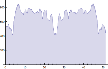
Last weekend I travelled with several friends from my cycling team (Wild Card Cycling) to hilly southern Illinois for a training camp. We spent 3 days riding on terrain a little more challenging than that of Champaign county. There were 20 people total.

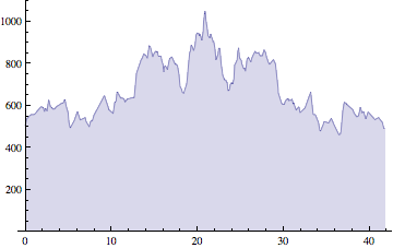
On Friday afternoon we did an out and back ride from Lick Creek to Bald Knob, one of the highest points in Illinois. The temperature was a little cool, but the sun was shining. The excitement of the group showed in the quick pace we set. I was assuming we would all stay together the whole way except for the big climb up Bald Knob. I was wrong. The groups frequently split up on the smaller hills and then those towards the back (often including me) had to chase hard to catch back up. We did all stop to regroup a few times.

On the way out it wasn’t so bad because I was relatively fresh. This was a sensation I would not feel again for a few days. The first third of the ride I could keep up with the stronger riders on the uphill sections, but it took a lot of effort. Everyone rode Bald Knob at their own pace. On the way back I was getting tired, but the pace of the group actually seemed to increase. I spent quite a lot of time off the back of the group chasing to try to get back on. With about 10 miles left I unhitched for good and rode alone or with one or two other stragglers to the finish.

It was a hard ride, a lot harder than I expected.

Distance: 41.94 miles
Duration: 2:23:34
Avg Heart Rate: 147
Max Heart Rate: 182
Calories: 2466
Total Ascent: 1180 feet
Weather: 54˚, sunny

Friday’s route

Friday’s elevation

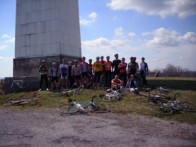
Wild Card Cycling team at the top of Bald Knob (photo courtesy of Karl)

After the ride, 8 of us travelled a short distance from Lick Creek to Giant City State Park, where we had cabins reserved. Giant City had a lookout tower which provided nice views.

Bald Knob was visible in the distance from Giant City State Park

8 of us stayed at the cabins at Giant City State Park

Martin, Rob, John S., John A., Don, Gene, John B., & Jay at Giant City

We ate dinner at the Giant City Lodge. The restaurant had 1 vegetarian option, steamed vegetables (and rice, and sides). Fortunately, it was absolutely delicious. Most of the other guys had the all-you-can-eat fried catfish dinner, for which the lodge is apparently famous. Needless to say, nobody left the lodge hungry, and some of us had a difficult time walking.

We got to bed relatively early in anticipation of a longer, harder ride on Saturday.

The Practice Start

Yesterday was the Earth, Wind, & Fire 5K run put on the by the Illinois State Geological Survey at the University of Illinois. The race started at 8 a.m. When I woke up at 6:20 a.m. the temperature was 13˚ F. This was going to be interesting.

The start was less than a mile from our house, so I ran over there to warm up. I registered for the race and waited around inside the Natural Resources Building until closer to race time. There was a Festival of Maps (I like maps) lining the hallway so I kept myself occupied. About 20 minutes before the start I ran another mile outside to warm up then I headed to the start line.

There were a surprising number of people there. I thought there would be maybe 20 of the most hardcore runners that braved the frigid weather and howling winds for this race, but I was mistaken. About 150 people showed up.

As everyone was mulling around near the starting line, trying not to freeze, the race directors decided to blow the air horn to test it out and make sure it was working. The thing is, they didn’t tell anyone what they were doing. As soon as the horn blew a few people took off running. Seeing them, everyone else took off running. The race directors were standing right in front of the line and all of the sudden the entire field was running around them. They quickly got on the bullhorn to announce that this wasn’t actually the start. The runners eventually stopped and headed back to the starting line. When it was time for the real start the directors were much more careful to explain exactly what was going to happen. Fair enough. They gave a 5 second count down then we were off.

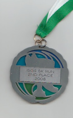
The race went surprisingly well given the poor weather conditions. I was able to pull out a 19:20, which was good enough for 5th place overall and 2nd in my age group. I guess I’m not as out of shape as I thought I was.

Since the race was put on by geologists, the winners received some sort of special rock as an award.

Update: They posted race photos, including a couple of me.

Rob finishing the 5K (photo courtesy of Joel Dexter)

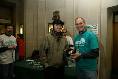
Rob receiving award (photo courtesy of Joel Dexter)

The Bonk

Several of my regular bicycling partners have started a racing team this year called Wild Card Cycling. This weekend we planned a long (even by my standards) training ride together. The plan was to do a century (100 miles). My previous longest ride of the year was around 50 miles or so, so this was a big jump. After 75-80 miles I bonked (*).

Bonking is basically the same thing that marathon runners refer to has “hitting the wall.” It is the point at which your muscles run out of glycogen and can no longer continue to function at their current capacity. In a matter of minutes you become incredibly tired and your heart rate skyrockets. You can keep going after you bonk, but your performance drops significantly. Your body has no stored carbohydrates so it has to burn only fat, which is a poor source of energy.

The only way to avoid bonking on really long workouts is to continue to eat during the workout. I was eating during the ride yesterday, but apparently it was not enough. After 4.5-5 hours or so my body stopped cooperating.

Fortunately, another guy bonked at roughly the same time and we were able to ride together the last 20 miles into town. It seemed to take forever. I ended up at home after 96.33 miles and decided not to do another 4 miles. I didn’t have it in me. I was past the point of enjoying myself anyway. There will be other days.

No “peddlers” allowed in Cerro Gordo

The route from Urbana to Cerro Gordo

This morning I did another 35 miles with the group. It took 20 or so miles to work the lactic acid from yesterday’s ride out of my legs, but I felt pretty good by the end. It was dark and rainy right until the end of the ride then the sun came out and it’s now a beautiful day. If only we had waited an hour.

(*) Incidentally, we used to ride with an Australian woman who informed us that “bonk” had a totally different meaning in her country.

The Glide

I’m starting to get the hang of skiing. As I watched the snow fall all day Friday at work my excitement grew. I had been hoping for one more good snowfall this season so I could get just a little more skiing in.

Friday night we had a dinner party with neighbors, then after that (around 12:30 am) I headed over to the Arboretum for about 20 minutes of skiing. The sledding hill was packed with (fairly uncooperative) people, most of which appeared to be college students. The snow was a little bit too powdery, but it was a good time nonetheless.

Saturday was supposed to be the big day. I ended up heading out to Allerton Schroth trail at about 2 pm. Unfortunately, much of the snow had melted (though it was still below freezing), and it was very spotty. That is, there was lots of bare ground that I had to try to avoid. So it was good, but not great. I thought the chances for good snow on Sunday were pretty slim.

Fortunately, I was proven wrong. The snow was actually fantastic. I again went over to the Arboretum. The snow was just a little icy, but not too much, and it was less spotty than it had been at Allerton on Saturday. In fact, I was skiing so well that I deviated from my original plan of doing a couple of loops at the Arboretum and just kept heading farther and farther out. There is some wooded area just across Windsor road. When I got to Windsor I took the skis off, ran across the road, put the skis back on, and kept right on going. The snow in this area was packed down and frozen just enough that I was able to glide nearly effortlessly along. After I skied in that wooded area for a while I crossed Race street and skied around at Meadowbrook park. I was now a few miles from home.

It felt so hot Sunday that I took my hat off. Then I took my gloves off (yes, skiing without gloves… it was weird). Then I had to roll up my sleeves. I had the foresight to bring a water bottle with me. Just when I reached to the back of my waist pack to get it the lid popped off and all my water spilled onto the snow. Crap. I guess it was time to head home soon anyway.

After lunch, I went back out for a 40 mile bike ride, which was somewhat enjoyable, though fairly boring. Everything looked like this:

You couldn’t really tell where the ground ended and the sky began.