The Highest Point in North Carolina

A few days after riding Clingman’s Dome (the highest point in Tennessee) I rode Mt. Mitchell (the highest point in North Carolina). That was four years ago today. The bulk of the climb was quite similar to Clingman’s Dome: not very steep, winding roads, not much traffic. However, Mt. Mitchell threw in a few surprises that made it quite a bit more challenging.
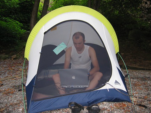
Rob computing

Just outside of Asheville, NC we turned onto the fabled Blue Ridge Parkway. This is a 500 mile scenic drive (no commercial traffic allowed) through east-central Appalachia. Once again, I rode my trusty Thundercougarfalconbird, while Melissa drove Iris the support vehicle. The road turned upward immediately as I rode away from Asheville.

Blue Ridge Parkway

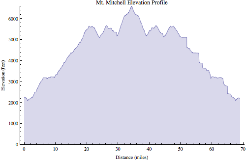
The first few hours (yes, hours) went smoothly. This part of the climb was not very steep. I settled into a steady pace. This climb (35 miles) was much longer than the two other mountains I had previously ridden, Clingman’s dome (20 miles), and Mt. Tam (10 miles). To put it in comparison, it dwarfs the climbs typically done in professional bike races (where 10 miles is a long climb, and virtually no climbs are longer than 12-15 miles). Of course, it wasn’t that steep though. Yet.

Mt. Mitchell

Around 5,000 ft altitude I noticed for the first time it was actually much more difficult to breathe. Around 5,500 ft I encountered a fairly long downhill section which caused me more worry than relief. Every inch I descended would be another inch I would have to climb again to reach the top. Before long the road went up again. Then back down again. Crap.

Mt. Mitchell

Finally, I reached the turn off of the Blue Ridge Parkway into Mt. Mitchell state park. This is where things got interesting. The road immediately hit 9% and stayed that way for 1.5 miles or so. After hours of climbing a moderate grade, this steep section really hurt. Fortunately, the top was very near, and I made it without incident.
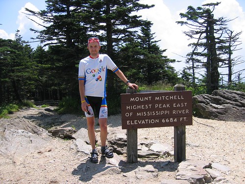
Mt. Mitchell

Mt. Mitchell

After a brief rest at the top came the fun part: 35 miles downhill (well, except for those two stupid dips which I had to ride up on the way back).
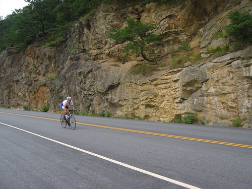
Mt. Mitchell descent

At one point I noticed a few cars backed up in the road, so I had to slow down. I wondered what was going on. There was nothing blocking the road so I gently eased around the stopped cars and continued on my way. As soon as I reached the front of the group I looked over to my right and noticed about 20 meters away from me was a bear walking along the side of the road. I coasted along as I stared at it, not believing my eyes. I was used to seeing dogs while cycling, maybe even deer, but this was a first for me. Anyway, I quickly came to my senses and hauled ass out of there. I had no desire to become this bear’s lunch.

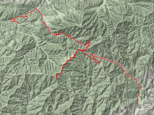
Mt. Mitchell map

Mt Mitchell profile

Ride Information
Date: 2005-08-11 8:50 AM EDT
Mountain: Mt. Mitchell
Road Elevation: 6585 feet
Climb Distance: 34.25 miles
Climb Ascent: 5956 feet
Climb Average Grade: 4.3%
Climb Maximum Grade: 9%
Ride Distance: 69.9 miles
Ride Total Ascent: 7472 feet
Ride Maximum Speed: 48 miles/hour
Ride Start: Asheville, NC (2194 feet)
Ride End: Asheville, NC (2194 feet)

The Highest Point in Tennessee

I enjoy cycling. Long time readers might recall that a long term goal of mine is to cycle to the highest point (well, highest paved road) in every U.S. state. The first one I checked off the list was Tennessee, four years ago today.

Living most of my life in flat, flat central Illinois I have a special appreciation for mountains. The first mountain I rode was Mt. Tam in California, in 2004. I rode it again in 2005, at which point I was hooked. I needed more mountains, but I had none near home. So I started looking around for places where I could take trips to ride mountains.

Having spent every summer during college working in central Appalachia I was somewhat familiar with this mountain range, plus it’s an easy day’s drive to get there. But where to go. If I was going to take a special trip I wanted some big, big mountains. The two biggest are Mt. Mitchell (6,684 feet, the highest point in North Carolina, near Asheville, also the highest point east of the Mississippi river), and nearby Clingman’s Dome (6,643 feet, on the TN/NC border, the highest point in Tennessee).

Iris packed for vacation

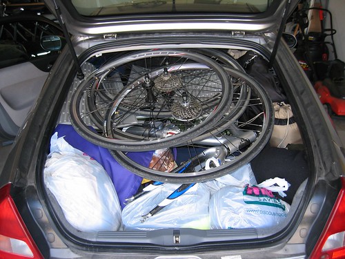
What started out as kind of pie-in-the-sky wishful thinking quickly turned into a week-long family vacation in August 2005 (i.e. best vacation ever®). We packed the Insight full of camping gear, food, clothes, and two (yes, two) bikes and headed to the Great Smoky Mountains National Park.

Camping at Great Smoky Mountains National Park

We camped in the park (just outside of Gatlinburg, TN) the first night and woke up bright and early, ready to tackle Clingman’s Dome: me on the bike, my wonderful wife driving the support vehicle. The ascent was 20 miles long and rose around 5,000 ft. The road wasn’t terribly steep (4-5%) since it was in the national park and it was built so RV’s could make it up.

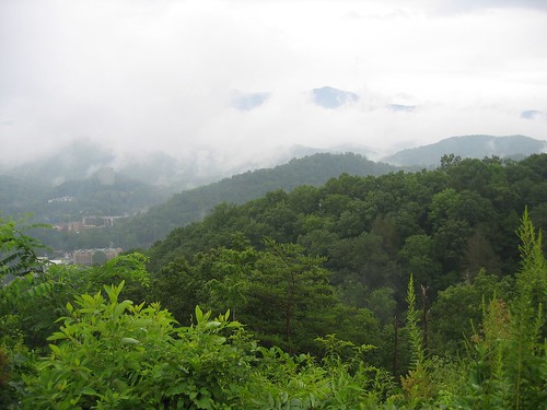
View of Gatlinburg, TN

The first mile or two was very easy. I was cruising along at 16-17 mph thinking this will be a piece of cake. The gradient increased gradually until I was closer to 8-10 mph, where I would remain for most of the climb. I didn’t know what to expect with such a long climb (twice as long as the only other mountain I had climbed), and since I have a double chainring I switched to a mountain bike cassette with a 32-tooth cog before the ride. I could have gotten by comfortably with a 28. My regular road cassette only had a 25. This would have been usable, but much more difficult.

Clingman's dome

The first 12.5 miles on Newfound Gap Road had just a little bit of traffic, but it wasn’t bad. All the cars were going very slowly anyway, so my presence didn’t seem to cause any problems.

Newfound Gap

At Newfound Gap I stopped to get new water bottles from Melissa, then turned off onto Clingman’s Dome Road for the final 7.5 miles. There was very little traffic on this road. Aside from a short downhill this road was also a little bit steeper.

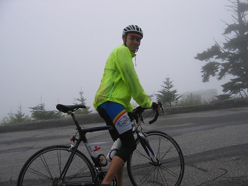
Rob at top of Clingman's Dome

What had been foggy and overcast weather all morning turned into a light drizzle at the summit of Clingman’s Dome. Fortunately, we made another trip back there a few days later for a better view from the observation tower at the top.

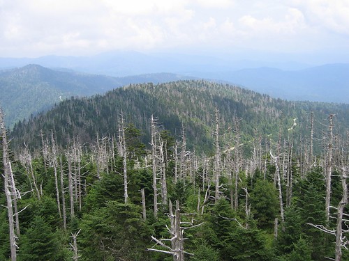
View from Clingman's Dome

Appalachian Trail at Clingman's Dome

I chose to descend the other side of the mountain, into North Carolina, rather than go back down the way I came up. Like the other side, this side wasn’t terribly steep, but it did have some long straight sections that relatively safely allowed for high speeds.

Rob on Clingman's Dome descent

This was only the third time I had ridden a mountain, so my descending skills were a little lacking. Nonetheless I was able to get up to 48 mph or so on the descent.

Clingman's Dome descent

At the bottom Melissa picked me up and we drove off to the next campground where we would continue our great adventure. I really enjoyed the ride up to and back down from Clingman’s Dome. It was challenging, but not ridiculous (like Mauna Kea). It was a good warmup for Mt. Mitchell a few days later.

Clingmans Dome map

Clingmans Dome  profile

I had some GPS wonkiness that caused the square looking sections

Ride Information
Date: 2005-08-08 7:39 AM EDT
Mountain: Clingman’s Dome
Road Elevation: 6318 feet
Climb Distance: 20.0 miles
Climb Ascent: 4837 feet
Climb Average Grade: 4.8%
Climb Maximum Grade: ?
Ride Distance: 50.6 miles
Ride Total Ascent: 5895 feet
Ride Maximum Speed: 48 miles/hour
Ride Start: Elkmont Campground, GSMNP, TN (2285 feet)
Ride End: Oconaluftee Vistior Center, GSMNP, NC (2046 feet)

A I mentioned, we came back to Clingman’s dome a few days later and parked at Newfound Gap. From there Melissa & I rode together the last 7.5 miles to the top. Despite her fear, I think she really enjoyed the ride. Conquering that mountain was certainly difficult for her. She often mentions that experience in the same breath as other difficult moments in her life (i.e. marathon #1, marathon #2, marathon #3, etc.) that have helped her learn to persevere.

The End of May

Photo of the Day

May 2009 Photo of the Day

Blog

The top searches that led to my blog in May:

  1. dahon helios [xl]
  2. my name is rob (or: rob is my name)
  3. bike friday pocket rocket
  4. mathematica 8 (again, doesn’t exist and I’ve never mentioned it)
  5. iPhone camera remote
  6. highest point in PA
  7. camel clutch

Running

Rob at start of Rockford Marathon

Most of my training and racing efforts in May were geared toward running. I raced four weekends in a row (sprint triathlon, 5K, marathon, 5K), all of which were quite successful. Now comes the time of year (i.e. the heat of summer) when I scale back my running and work more on cycling and swimming.

Month Distance # Workouts Avg per Workout
January 109.34 Mile 10 10.934 Mile
February 55.83 Mile 7 7.97571 Mile
March 108.792 Mile 10 10.8792 Mile
April 74.85 Mile 8 9.35625 Mile
May 64.5669 Mile 9 7.1741 Mile
Total 413.378 Mile 44 9.39496 Mile

Cycling

Rob finishes the bike

I did no cycling races (aside from the triathlon) and only a little training in May. My bike mileage was half of what it was in May of last year and I’m a good 800 miles behind where I was last year at this point. I’ve completely given up two of my four/five weekly training rides from last year to spend more time with the family.

Having said that, I’m doing surprisingly well on the bike. I think it’s mostly my running fitness carrying over and making up (slightly) for my lack of training miles.

May 2009

Bike Distance # Rides Avg per Ride
Bianchi 48. Mile 12 4. Mile
Big Red 3.2 Mile 1 3.2 Mile
El Fuego 14.5 Mile 2 7.25 Mile
Pocket Rocket 7.2 Mile 2 3.6 Mile
Thundercougarfalconbird 274.93 Mile 7 39.2757 Mile
Total 347.83 Mile 24 14.4929 Mile

January-May 2009

Bike Distance # Rides Avg per Ride
Bianchi 300. Mile 64 4.6875 Mile
Big Red 7.17 Mile 3 2.39 Mile
El Fuego 54.42 Mile 7 7.77429 Mile
Pocket Rocket 120.93 Mile 25 4.8372 Mile
Thundercougarfalconbird 1027.65 Mile 24 42.8188 Mile
Total 1510.17 Mile 123 12.2778 Mile

Swimming

The spring session of Masters Swimming ended with another practice meet. I dropped my 500 yard freestyle time from 7:10 at the last meet to 6:48 at this meet.

After a couple weeks of little-to-no swimming the summer session of Masters Swimming started up and it has been going well so far. The morning schedule works out better for me (i.e. doesn’t conflict with group run and/or bike workouts), so I may be swimming as many as four times per week (rather than two times per week throughout the school year).

This bodes well for my chances at the Olympic distance triathlon(s) this summer. This category of race is more swim-heavy than other distances. Between July and September of last year I dropped my 1500 meter swim split from 28+ minutes to 25+ minutes, and I’m already doing much better than that so far this season. It’s conceivable I could swim four minutes faster, bike the same time, and run one minute faster at this year’s Evergreen Tri, knocking five minutes off my time from last year. I would be extremely pleased with that.

Month Distance # Workouts Avg per Workout
January 1.87452 Kilo Meter 3 0.62484 Kilo Meter
February 14.9504 Kilo Meter 6 2.49174 Kilo Meter
March 19.5224 Kilo Meter 7 2.78892 Kilo Meter
April 13.3502 Kilo Meter 6 2.22504 Kilo Meter
May 12.7806 Kilo Meter 7 1.82579 Kilo Meter
Total 64.7782 Kilo Meter 30 2.15927 Kilo Meter

The Domestic Travels

I enjoy traveling, and I love geography, so I was very excited when a friend of mine recently mentioned this website that allows people to track their travels, county by county, across the country. I spent a couple hours entering my data (thanks to some helpful information from my dad regarding trip routes from my childhood) and now I have this wonderful map.

Click to enlarge

I categorized the counties thusly:

In cyan (light blue) are places where I’ve traveled in an automobile (or other motorized land vehicle). These include:

  • Seattle/Olympic National Park
  • Silicon Valley
  • Grand Canyon
  • El Paso/Juarez
  • Dallas
  • Galveston
  • New Orleans/Baton Rouge
  • Nashville
  • Des Moines
  • Minneapolis
  • Green Bay
  • Sault Ste. Marie
  • Cedar Point/Sandusky
  • Washington DC
  • Wilmington, NC
  • Hilton Head, SC/Savannah, GA
  • Hawaii & Kauai islands
  • Most of Illinois, Indiana, and central Appalachia
  • Everything along the way to these places

In magenta (light purple) are places where I’ve been bicycling (and probably travelled by auto also). These include:

In dark blue are places where I’ve been, but only in the airport (i.e. I had a layover there). These include:

  • Los Angeles
  • Phoenix
  • Salt Lake City
  • Kansas City
  • Atlanta
  • Miami
  • Honolulu

It’s exciting to remember all the great places I’ve been, and just as exciting to think about all the places I have yet to explore. I’ve still never set foot in 19 states:

  • Maine
  • New Hampshire
  • Vermont
  • Massachusetts
  • Rhode Island
  • Connecticut
  • New York
  • New Jersey
  • Delaware
  • Alabama
  • Nebraska
  • South Dakota
  • North Dakota
  • Colorado
  • Wyoming
  • Montana
  • Idaho
  • Nevada
  • Alaska

I’ve got places to go. Hopefully I will keep the map updated along the way.

The Highest Point in Maryland

On my way back from Washington D.C. last weekend I took the opportunity to knock another state off my list of high-points-to-which-I’ve-bicycled. The previous Friday it was Pennsylvania. Monday it was Maryland’s turn. Backbone Mountain, the state’s high point, is nestled in the far western corner of the state, within walking distance from West Virginia.

I spent a good deal of time studying the area with Google Earth on Sunday night in my hotel room. Oakland, Maryland was the clear choice for my starting point. This was only 25 minutes off I-68. The actual peak is not accessible by any road, so I made due with the highest point on the closest road to the peak (U.S. 50), which was conveniently labelled as the Highest Point on the Maryland State Roads System. Perfect.

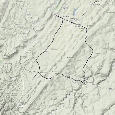
I had a little bit more time for this ride than I did a few days prior in Pennsylvania, so I decided to do a slightly longer ride and make it a loop instead of simply turning around once I reached the top. Since I would be riding down the other side of the mountain, this meant that I would actually have to ride back over the mountain a second time on a different road in order to return to my starting point. The temperature was a chilly 39˚ when I started, so I bundled up.

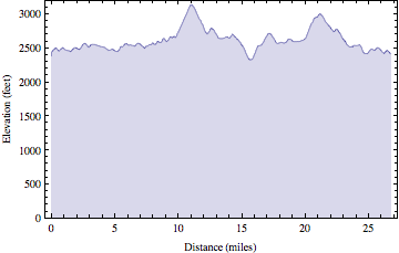
Backbone Mountain ride map

The unfamiliar roads and dense fog made for some interesting navigation challenges. Like Pennsylvania, there were many rolling hills as I started the loop on U.S. 219. Soon after I turned onto U.S. 50 the road turned upward. The climb itself was shorter than Mt. Davis was a few days prior, but it was much steeper. I spent some quality time in my lowest gear moving along at what seemed like a snail’s pace, but I made it. Six states down (TN, NC, KY, HI, PA, MD), 44 to go.

Rob at the top of Backbone Mountain

Plaque at the top of Backbone Mountain on U.S. 50

I descended the mountain, turned a corner, then started going back up it again, only this time I was on a different road. The second climb seemed roughly the same length and steepness as the first, though it was even foggier. Again I spent much time in my lowest gear. From the top I coasted most of the rest of the way back to Oakland.

Backbone Mountain ride elevation profile

Once back in town I picked up a 12″ veggie sub on wheat bread with pepper jack cheese, lettuce, onions, tomatoes, pickles, green peppers, & black pepper from Subway. Unfortunately, I didn’t realize until I was driving out of town that the “lemonade” was actually some kind of disgusting carbonated junk instead. I think they must have had some hoses crossed in the fountain machine.

It was a nine hour drive back to Urbana from there. Interestingly, an hour or so later the temperature in West Virginia was around 70˚ and I was actually hot for most of the rest of the trip.

High Point Ride Information
Date: 2008-04-07 9:52 AM EDT
State: Maryland
High Point: Backbone Mountain
Elevation: 3095 feet
Climb Distance: 1.14 miles
Climb Ascent: 469 feet
Climb Average Grade: 7.8%
Climb Maximum Grade: 12%
Ride Distance: 26.8 miles
Ride Total Ascent: 2656 feet
Ride Maximum Speed: 38 miles/hour
Ride Start: Oakland, MD (2372 feet)
Ride End: Oakland, MD (2372 feet)

The Highest Point in Pennsylvania

It’s not widely known outside of this household that I have a goal to bicycle to the highest point in all 50 states. Well, at least the highest point that is accessible via bicycle, generally on a paved road. It is a lofty goal indeed, but I’m not super strict about the rules… and I’m not in any huge hurry. I just like riding.

As of last week I had 4 states down, including some big ones (Tennessee, North Carolina, Kentucky, & Hawaii). When I was planning my trip to Washington D.C. this past weekend I took a quick glance at some web sites and saw that Pennsylvania & Maryland had high points that were not very far out of my way (additionally West Virginia, Ohio, & Indiana, but I thought two would suffice for a single weekend). So I took my bike and thought if I had time I would ride them, if not no big deal.

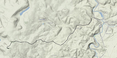
The route from Meyersdale to the summit of Mt. Davis

I drove for nine or so hours by the time I reached Meyersdale, PA, at the foot of Mt. Davis. The weather was nice, and I was sick of driving, so I rode. As I was coming into town I noticed there were many wind generators perched atop the rolling hills. As soon as I stepped out of the car I realized why. It was windy. Really windy. And unfortunately, it was going to be a headwind the entire way up Mt. Davis.

Wind generators near Meyersdale, PA

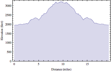
The elevation of Meyersdale was 1935 ft. and the summit of Mt. Davis is 3213-ish ft. So it was a decent change in elevation, but it was no Mauna Kea. As I began the 10 mile ride to the summit I quickly realized this climb was going to be a little different than many of the previous mountains I have ridden. It was really just one large rolling hill after another. It wasn’t very steep (the average grade was 3.2%, with one short 13% section). There were no switchbacks. The strong headwind made it tough, and I didn’t have the best legs after nine hours of driving, so it was slow going.

A sign directing visitors to Mt. Davis with rolling hills in the background

I rode through lots of farmland and passed many people I assume were Amish. There were several horse drawn buggies and a few diesel powered tractors (diesel is apparently okay for the Amish). Everyone waved and seemed rather friendly.

Towards the top the landscape finally turned from large rolling hills into a real actual climb. It got a little steeper at this point, but it was still managable. There was a picnic area at the summit, a sign indicating the significance of the location, and a short distance away was an observation tower. The wind made walking up the tower stairs an interesting experience, but I survived.

Rob at the summit of Mt. Davis, PA

View of Meyersdale, PA from observation tower at summit of Mt. Davis

Mt. Davis ride elevation profile

The long, straight roads and strong tailwind allowed for some fast descending. At one point I passed a group of Amish children who all waved to me as I sped past at 35 mph. When I returned to Meyersdale, I packed up my bike, got back in the car, and drove the remaining three hours to D.C. It was a good way to break up the monotony of driving such a long distance in one day.

High Point Ride Information
Date: 2008-04-04 3:19 PM EDT
State: Pennsylvania
High Point: Mt. Davis
Elevation: 3213 feet
Climb Distance: 3.5 miles
Climb Ascent: 1010 feet
Climb Average Grade: 5.4%
Climb Maximum Grade: 13%
Ride Distance: 19.4 miles
Ride Total Ascent: 1973 feet
Ride Maximum Speed: 45.7 miles/hour
Ride Start: Meyersdale, PA (1935 feet)
Ride End: Meyersdale, PA (1935 feet)