Longs Peak

Planning

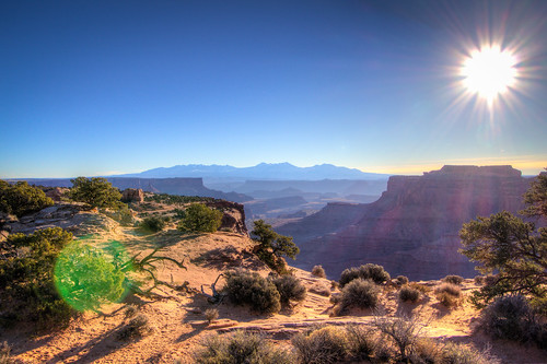
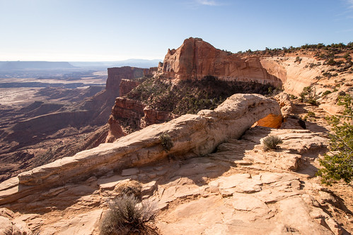
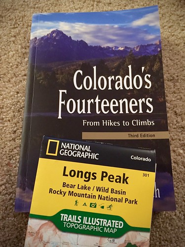
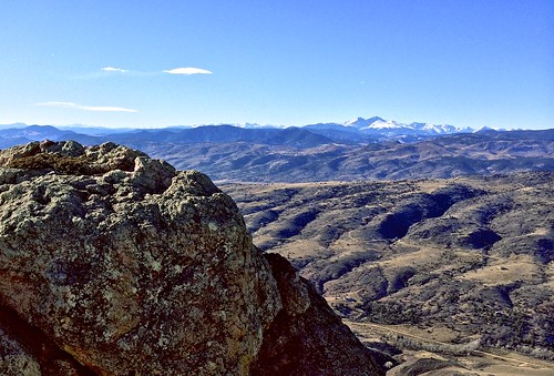
There’s only a short window of a few weeks each year when it’s (relatively) safe to climb Longs Peak without an ice axe (which I don’t have and don’t know how to use). Longs is the closest mountain over 14,000 ft to Fort Collins, in nearby Rocky Mountain National Park. It looms large over everything here. I can’t actually see it from my house because closer mountains obstruct the view. But it is visible farther east (where I rarely go) and from the summit of Horsetooth Mountain (where I go much more frequently).

IMG_7805

I missed the window last summer to climb it and I didn’t want to miss out again this summer. Longs is the most frequently climbed 14,000 ft mountain in Colorado–not because it’s the easiest, because it’s the most accessible. That means it also attracts the greatest number of people who are completely unprepared, both in terms of fitness and in terms of technical skill. As a result, Longs is responsible for more deaths than any other 14,000 ft mountain in Colorado.

So I wanted to climb it, but I wanted to do so safely. I sent a message out to a handful of friends and I got one bite, my friend Curtis. We drove up to the trailhead early one Saturday morning in August to find the parking lot completely full and cars parked along both sides of the road for about a half mile back. This was around sunrise. Most people got a much earlier start than we did, but we were planning to move pretty quickly. Regardless, we certainly didn’t expect that many cars.

Starting around 9,400 ft, we alternated running and hiking in the early miles as the grade varied a bit. We took the standard, most common route via The Keyhole. The trail was actually pretty horrible. Rather than a smooth uphill the trail had hundreds (thousands?) of stairs built in, so people put a lot of intentional effort into ruining it. There was no regularity to the spacing of the stairs, so each one took a different number of steps to get up. It was awful for running, though I’m not sure I would even want to hike on a trail like that.

The Diamond

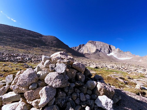
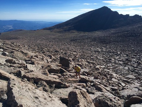
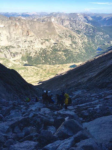
Once we got up to 12,000 ft there wasn’t much more running uphill, but we still hiked quickly. At The Boulder Field the steps thankfully ended, but so did the trail for a bit. We just had to hop across hundreds of huge rocks going in the general direction of The Keyhole.

The Boulder Field

After The Keyhole come the dangerous parts. First is The Ledges, which wasn’t as bad as I had feared. Yes, the trail is narrow. Yes, there is a pretty big drop off. But it was dry and if you paid attention to what you were doing there was very little real danger.

The Ledges

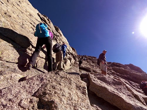
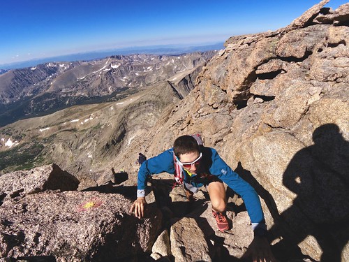
After The Ledges the trail turned sharply upwards into The Trough. Remember all the cars in the parking lot? This is where all the people were. We had only passed a couple dozen people earlier in the trail, but this is where everyone was bunched up. Fortunately, there were a few different lines up the trough so it was relatively easy to pass people. The dangerous part through here was all the loose rock that would occasionally go tumbling down when people took a wrong step. Some people were wearing climbing helmets, and frankly, that wasn’t a terrible idea.

The Trough

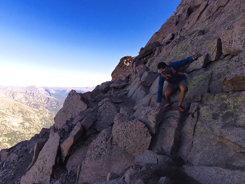
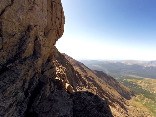
At the very top of The Trough was the hardest part of the climb–an actual climb. It was only about 10 feet high, but everything else on the trail is nothing more than a scramble. Once through The Trough we got to The Narrows, which lives up to it’s name. The trail is narrow. There is a huge drop off. Again, just pay attention and all will be well.

The Narrows

The Narrows

Once past The Narrows we made it to The Homestretch, which is where the other half of the people were. In some places there were two lines up The Homestretch and I could pass people, but in other places there was only one line and I had to wait.

The Homestretch

The Summit

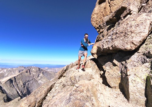
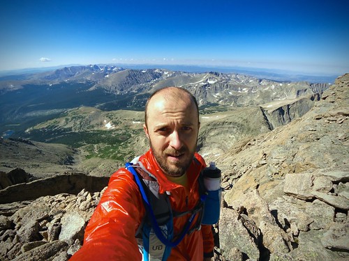
Soon enough we reached the summit. It’s a weird, completely flat area about the size of a football field at 14,259 ft. Parts of The Keyhole, Trough, Narrows, and Homestretch had been windy and cold, but the summit was perfectly calm. There were no clouds for hundreds of miles in any direction.

Longs Peak (14,259 ft)

We were cautious but quick on the descent. There would soon be a mass exodus by the hundreds of people at the summit before the afternoon thunderstorms rolled in. I wanted to beat the crowd. Most of the scrambling sections I crab-walked down, facing outward. I kicked more loose rock down The Trough than I would have liked, but fortunately none of it hit anybody.

It was blazing hot by the time we made it back down to The Keyhole and The Boulder Field. We had picked the hottest day of the year to do this. On the long run back down the trail both Curtis and I ran out of water (we packed a lot) and started to get dehydrated. We stumbled a bit, both falling down a couple times. We finally made it back to the car where I had a big jug of ice cold water waiting. We had successfully climbed Longs Peak and made it safely back down to the bottom. At times it wasn’t pretty, but we almost certainly weren’t the least prepared people on the mountain that day.

Canyonlands

Canyonlands NP

I wasn’t super familiar with Canyonlands National Park before my trip to Moab, UT in February. Even though I was a bit short on time, I had to pay a quick visit on the Sunday morning after the Red Hot 55K before I headed back home. In short, I was blown away.

In the park is the confluence of the Colorado River and the Green River. The two rivers form deep canyons that, with no bridges within the park’s boundaries, separate the park into three separate districts that are quite a long drive apart from each other. So I just visited the Island in the Sky District closest to Moab.

Canyonlands NP

Canyonlands NP

I drove the entire length of the road in that district, stopping at every overlook to stretch my sore legs and take in the scenery.

Mesa Arch

Canyonlands NP

Canyonlands NP

Canyonlands NP

Canyonlands NP

Leap

Canyonlands NP

Canyonlands NP

The 3 miles I hiked did wonders for my legs after the race and before the long drive home. What should have been a 6 hour drive turned into 11 as I got caught in a whiteout blizzard crossing the Rockies before I even reached the weekend ski traffic that was all headed back to Denver at the same time. So my afternoon and evening weren’t nearly as pleasant as my morning.

Anyway, I anticipate returning to Canyonlands at some point in the future. With a bit more time I’d love to see the other two districts of the park as well.

The Saddle

With next weekend’s Mt. Werner Classic 50K rapidly approaching I felt the need to get in one more good run up above 10,000 feet. Saturday morning I woke up before dawn and drove to Rocky Mountain NP. We have an annual pass for the park, but I wouldn’t have needed it as I arrived before the gate attendants were on duty.

My plan was to run the Lawn Lake Trail up to Lawn Lake, then perhaps The Saddle, then perhaps beyond. Four weeks prior I ran the Black Canyon Trail to Lawn Lake, but this route would only share about ½ mile of trail in common with that route.

Lawn Lake Trail

The trail began steep, gaining 500 feet in the first mile, then eased up a bit into a more comfortable running grade. I passed a couple hiking in the first few miles. They would be the last humans I would see for several hours.

The trail closely follows the Roaring River, which was the source of the massive flooding last fall. The banks of the river were just destroyed by the flooding nearly all the way up to Lawn Lake.

Lawn Lake Trail
Looking upstream

Roaring River, Trail Ridge Road, Longs Peak
Looking downstream at Trail Ridge Road and Longs Peak off in the distance

Roaring River

Like the other trails I’ve run in Rocky Mountain NP the surface varied quite a bit from smooth to rocky.

Lawn Lake Trail

Lawn Lake Trail

Lawn Lake Trail

Mummy Mountain

After about 6 miles I caught glimpse of The Saddle up ahead and soon I reached Lawn Lake at 11,000 feet.

The Saddle
The Saddle

Lawn Lake Trail

I had a pretty easy week of training last week, so I was feeling pretty good by this point and I pressed on.

Lawn Lake Trail
Mummy Mountain

Lawn Lake Trail
Origin of the Roaring River

Lawn Lake Trail
Mummy Mountain

The last mile of the trail was quite a bit steeper and I was reduced from a run to a fast hike. The warm sun was heating me, while a cold headwind chilled me. I was both hot and cold at the same time.

I reached The Saddle, the low point between Fairchild Mountain and Hagues Peak. The trail basically disappeared into the tundra. The wind was blowing 30-50 mph up there. I looked both mountains up and down and decided to continue on up a ways on the less intimidating Fairchild Mountain.

Fairchild Mountain
Fairchild Mountain

Hagues Peak & Mummy Mountain
The Saddle, Hagues Peak, Mummy Mountain

I ascended a couple hundred feet more (12,700 feet) to get a good look at the other side of the mountain, and it was breathtaking.

Desolation Peaks
Desolation Peaks (I think)

Rob on Fairchild Mountain

It would have been nice to continue on up to the summit at 13,500 feet, but walking up that ridge in 30-50 mph winds left me, well, downright scared. Maybe some other time.

The run back down went pretty quickly, aside from a couple of navigation checks where the trail wasn’t completely obvious. I started to pass hikers on their way up, more and more the further I descended.

Lawn Lake Trail

The best part was that running felt relatively easy, even above 11,000 feet (my next race tops out at 10,500 feet, but several miles are above 10,000 feet). Sure, I was going downhill, but you may recall I had some problems even going downhill at high elevation during the Leadville Trail Marathon last month. This is a good sign.

Flattop Mountain

Last weekend I had the brilliant idea to drive up to Rocky Mountain National Park again for a nice long run up another big climb. I was apparently not the only one who planned something along those lines.

Rocky Mountain National Park

After waiting in lots of stop-and-go traffic all the way through Estes Park and up to the park entrance I finally made it in. Now I can relax. Except as I’m driving toward my preplanned trailhead parking lot I pass multiple signs saying all parking lots are full and suggesting I come back in a few hours. Grrr. Like everyone else on the road I proceeded anyway and reached a full parking lot. I drove multiple laps around the lot before seeing the shuttle bus had arrived and it was dropping off people coming back to their cars from Bear Lake. I picked out a couple, stalked them back to their car, and pulled into their parking spot the instant they left. Now after noon, I can finally get started.

Overflow parking lot full

This trail started at 8,600 feet, and (as the full parking lots indicated) it was much busier than the last one I ran at this park. I don’t know if it was the holiday weekend, the fact it was later in the day, or most likely this was simply a much more desirable location.

First, I reached Bierstadt Lake (9,300 feet), which was nice.

Bierstadt Lake

Next, I climbed and descended a few miles up the trail to reach Bear Lake (9,400 feet), which was also nice (and also much more crowded).

Bear Lake

After Bear Lake the trail got steeper. It varied quite a bit from smooth and runnable, to much rockier and hike-worthy.

Flattop Mountain Trail

Flattop Mountain Trail

I started to hit some leftover snow around 10,200 feet, but before long I was above tree line (11,200 feet) and I had sweeping views of the mountains all around me.

Flattop Mountain Trail

Flattop Mountain Trail

Flattop Mountain Trail

About that time I heard thunder. I turned around and saw this.

Flattop Mountain Trail

Not a good sign. The clouds appeared to be moving away from me, and I was almost to the top where it was still bright and sunny. So I forged on. I slogged through a small snowfield.

Flattop Mountain Trail

Flattop Mountain Trail

And finally I reached the top (12,324 feet). Given the name of the mountain I shouldn’t have been surprised the actual summit was not terribly interesting in and of itself.

Flattop Mountain

Flattop Mountain

This was the first time I’ve run up to and along the continental divide. I had hoped to run further out along the flats up there at 12,000 feet, but the weather was actually getting closer to me. So I started hauling ass down the mountain. Within minutes I was being pelted with hail.

Hail

At first it just stung a little bit, but the pellets grew larger and seemed to be coming faster and thicker. I was wearing a visor and the top of my head was really hurting by this point. I took my jacket out of my pack and sheltered my head as I began walking. Now my hands and elbows were taking the brunt of the impact, which didn’t feel great, but at least it wasn’t my skull. After several painful minutes the hail eventually subsided and I could run again without covering my head. I made good time. Soon enough the sun came back out.

The lower trails were muddy from all the rainfall during that popup storm, so the rest of the descent didn’t go quite as quickly as I expected. Eventually I made it back to my car in the now nearly empty parking lot and began the drive home.

Overflow parking lot not full

It was quite an adventure. Surely it would have been better without the storm. At least I was somewhat prepared, with extra gear to handle the weather, plenty of food and water, and a GPS beacon in case of emergency. Since these storms are much more common in the afternoons I should probably plan future adventures for mornings instead.

Black Canyon and Lawn Lake

While we were up in Estes Park for Melissa’s marathon, I managed to sneak in an epic mountain run. Starting from the Lumpy Ridge trailhead I took the Black Canyon trail up to Lawn Lake in Rocky Mountain National Park.

Big Thompson River Canyon
Driving up Big Thompson River Canyon to Estes Park.

The run started easy enough with smooth wide trails, gently rolling terrain, and beautiful mountain views.

Black Canyon Trail
Longs Peak just left of center

Black Canyon Trail
The Needles

After climbing 500 feet or so the trail grew more narrow, rocky, and tree covered.

Black Canyon Trail

Black Canyon Trail

There was a short section that appears to have been taken out by an avalanche or rock slide.

Avalanche damage?

Above 10,000 feet I started to see snow, and the trail got a little wet in a few places from all the snow melt.

Black Canyon Trail

Black Canyon Trail

After a bit the snow was much more prevalent. It covered the trail in many places, making navigation a bit tricky. It was super slippery and often off-camber. With each step I didn’t know whether the snow would support me, or whether I’d sink up to my knee, or whether I’d slide off to the side. It made for slow going.

Sometimes the snow made navigation difficult

Black Canyon Trail

There was snow above 10,400 ft

Sometimes the snow made navigation difficult

The Black Canyon trail I was on eventually (a mile farther than the map I used for planning indicated) met up with the Lawn Lake trail at the Roaring River.

Black Canyon Trail

A bit farther, at 11,000 feet (just below tree line), was Lawn Lake in all its splendor.

Lawn Lake

Lawn Lake
Apparently the shore where I’m standing used to be under water before the dam collapsed in 1982.

Lawn Lake

The views were totally worth the hours of running and hiking it took to get there. Of course, shortly after I arrived the weather turned and it began to rain on me. It was already a bit chilly at that altitude. I put on my jacket and started to run back down. In what seemed like a matter of minutes I went from chilly, rainy, with numb hands to sweltering heat and baking in the bright sun.

Black Canyon Trail

The 19-20 mile round trip took a bit longer than I anticipated. This was partly due to incorrect (low) distance estimates, partly due to the heavy snow cover in places, and mostly due to my tired legs after last weekend’s marathon and two hard hill workouts this week (14,000 feet total ascent in the last 8 days, by far the most I’ve ever done). I ran out of water and the last couple miles were pretty rough, despite the relatively easy terrain. But Melissa and Will were waiting for me at the parking lot with a cooler full of cold water and I pepped back up pretty quickly.

The next time I’m up at Rocky with time for a long run I’d definitely consider doing this one again. With fresher legs, more drinking water, and less snow on the trail this would be much easier. I might even be able to continue on up to the surrounding mountain peaks. Though, I understand there’s many great places to run there, and it might be hard to justify doing the same route again when there’s so much else to explore.

This is just the beginning.

The Long Way Home

The day after the Leadville Trail Marathon we had to check out of our hotel room by 10 AM and we had no plans the rest of the day. So we decided to take a scenic drive to nearby Independence Pass (12,095 ft).

Twin Lakes

Midway up Independance Pass

Independance Pass

Independance Pass

Then we proceeded home on the usual route over the less interesting Fremont Pass (11,318 ft).

Then I figured while we were taking scenic drives we might as well skip the Eisenhower Tunnel and take Loveland Pass (11,990 ft) instead (where we saw people skiing in June at Arapaho Basin).

Skiing in June

Ah, screw it. Instead of taking the interstate back, let’s take US-40/34 over Berthoud Pass (11,307 ft)…

Milner Pass (10,759 ft), and on through Rocky Mountain National Park on Trail Ridge Road (12,183 ft).

Finally, we passed through the beautiful Big Thompson Canyon, which was still being rebuilt from the massive floods last fall.

Big Thompson River Flood Damage

What should have been a simple 2h45m drive home turned into an all day affair. Melissa and Will were really struggling by the end, but they were good sports. After all it was Father’s Day and I appreciate them humoring me. I don’t think I will ever tire of driving through the mountains.

I love Colorado.

In the Dry Country

Clinton Gulch Reservoir

From my love of maps and geography at a young age through my current passion of trail running, Colorado has always fascinated me. Yet I’ve lived nearly 35 years without ever paying a proper visit to the state (the one time I was in Colorado was a layover in the Denver airport). That would all change with our family vacation this summer.

After our adventure at Howl at the Moon we spent Will’s birthday with both sets of his grandparents. Then we drove west. From the time Will was very little he didn’t travel particularly well, so we’ve rarely gone more than 3-4 hours in the car for the past few years. He handled the extended drive rather well now that he’s a mature 4 year old. Melissa has detailed our adventures here and here.

We spent the first night at a hotel beside the interstate in eastern Colorado, before heading on to Fort Collins the next morning. Fort Collins reminded me a lot of Champaign-Urbana, our former home. Except better in many ways. It has just about the best bicycling infrastructure of any city I’ve ever seen, and that’s saying something.

Despite the adjacent mountains, the city is flat. There was one road with heavy (if slow-moving) automobile traffic, but every other street in the city was completely ridable. Every arterial road had wide traffic lanes plus dedicated bike lanes. Plus cars drove at sensible speeds and didn’t take stupid risks for no apparent reason. Most secondary roads also had wide traffic lanes plus dedicated bike lanes. By the time you hit roads small enough to not have dedicated bike lanes there was essentially no automobile traffic. I didn’t actually ride in Fort Collins, but it was obvious this city would be extremely easy to get around by bike (better than C-U, and way better than Saint Louis).

We camped that night at Horsetooth Reservoir, just west of the city in the foothills of the Rocky Mountains. While this location kind of paled in comparison to what was to come, it was still a magical place to stay our first night in the Rockies.

Horsetooth Reservoir

Reservoir

Pitched

The next morning I awoke with a dry throat. Sure, we live nearly at sea level and we were now a mile above. The thin air was noticeable to me at this altitude, but not enough to bother me. The thing that did bother me, and I honestly wasn’t expecting this, was the dryness of the air. Nobody told me Colorado was essentially a desert. I was expecting the mountains and forests and rivers, but not necessarily the stark red earth and dry air.

We went for a hike at nearby Horsetooth Mountain. As I was carrying a 4 year old on my back at unfamiliar elevation and recovering from a long hard race effort, we opted for an easy hike rather than try to summit the peak. We had a fun time.

Horsetooth Falls Trail

After Fort Collins we drove to Rocky Mountain National Park for a few days of camping and hiking there. We drove through Big Thompson River Canyon, which was unbelievable. Given this was my first time in the Rockies, I was blown away by the mountains. This felt like an entirely different planet from the Appalachian mountains, where I’ve spent a considerable amount of time.

Rocky Mountain National Park

We camped at almost 9,000 ft. I went for a short run (my first run post-Howl) in the morning. I felt it all–the thin air, the dry air, the wild temperature swings. I saw moose and elk. I saw the mighty Colorado River where it’s just a creek, not even big enough to be given a name in the midwest.

Timber Creek Campground

Camping with moose

Wildlife

Rocky Mountain National Park

Colorado River

After breakfast we went out for a family hike along the Colorado River.

Colorado River

Colorado River

Colorado River

Rocky Mountain National Park

In the afternoon we went for another hike to Adams Falls.

Adams Falls

The following day we did some very light hiking at 12,000 ft.

Tundra

After Rocky Mountain National Park we went to visit Boulder. I expected Boulder to quite similar to Fort Collins, but it was remarkably different. It was reassuring to see dozens upon dozens of recreational cyclists out in the middle of a workday as we approached. But Boulder reminded me a lot more of Saint Louis than Champaign-Urbana. The roads were narrow. Most bikes I saw were on the sidewalk. There were a lot of people driving like maniacs trying to get somewhere in a hurry. I thought Boulder was supposed to be laid back…

North Boulder Park

We played at a playground, drove around the city, ate vegan fast food at Native Foods, then headed to a hotel for the night. I woke up early the next morning and drove by myself to Green Mountain on the edge of town. I ran from the bottom (5,600 ft) to the top (8,100 ft), taking far more time to do so than I care to admit. The altitude was a struggle for me, but I feel like I had it under control by going slowly. The dry air just about destroyed me. I was breathing the dry air so heavily that my throat just burned most of the way up. I ran out of water long before I reached the top. Upon reaching the summit I stood on the rocks at the top and had a great early morning view of Boulder. I signed some kind of register at the peak (Colorado Mountain Something Something Group) indicating I had been there. I was the only non-Colorado resident on the page. The descent was way easier (except when I had to go off trail to get around a very large snake in the path).

Boulder's Green Mountain

We met Melissa’s friend and her family and played at a park together before walking to a restaurant for lunch. Boulder was way more enjoyable on foot than it was in a car. After lunch we were off to Leadville. It wasn’t actually until the first morning we woke up in eastern Colorado that I realized we would be in the state while the famous Leadville 100 mile trail race took place. We decided to head further into the mountains to be there to watch the race finish.

Now above 10,000 ft, with a sore throat from breathing the dry air for a week, I really didn’t feel spectacular in Leadville. I literally found myself panting after jogging across the street, and again after walking up two flights of stairs in the hotel. We watched the first two finishers cross the line, Ian Sharman and Nick Clark. Both of these guys were in Nicaragua at Fuego y Agua this year. Ian ended up not racing Fuego y Agua (and I didn’t actually meet him), while Nick won the 100K after running with me for the first 11 miles and going off course twice. Kudos to them both. Given the difficulty I faced jogging across the street I can’t imagine running 100 miles at and above this elevation. Well, not yet. The next morning Melissa went for a run and claimed to enjoy it. I’m not sure I would have been able to.

Sharman

Clark

Our last stop in Colorado was a fun trip on an old mining railroad (Will loves trains). Then came the long, long drive back home.

Georgetown Loop Railroad

Georgetown Loop Railroad

Georgetown Loop Railroad

Swim Tech II: Garmin Forerunner 910XT

I’m a data junkie. I have a log of every workout I’ve done for the past 11 years, not to mention years worth of GPS tracks. When I run or bike my GPS records my distance and time. Even if I have technical difficulties and the GPS malfunctions for some reason I’m still pretty good at estimating distance. I don’t have that skill with swimming.

My new waterproof iPod Shuffle has been great for my swim training. It helps me deal with the boredom of swimming laps in a 25 yard pool. I can just let my mind go while the laps fly by. But I still need to know how far I’ve gone. I just can’t not know. That’s where the Garmin Forerunner 910XT
comes in.

Swim mode

The reason I bought this GPS watch was for running very long distances (it has much longer battery life than Garmin’s other GPS watches). I didn’t need it for cycling, I have a different Garmin GPS for that. I didn’t need it for swimming, I can count laps (though that does become difficult past 400 yards) and look at the timer clock on the wall. But now that I’m listening to music and swimming longer intervals (up to 1000 yards), not to mention I’m getting old, I can’t reliably count laps.

I really just stick to the basic swimming features of this watch. I tell it I’m swimming. In a pool. Which is 25 yards long. Then I swim. At the beginning and end of each interval I press the Lap button. The watch uses a built-in accelerometer to determine which stroke and which direction I’m going, from which it keeps track of how far I’ve gone.

(I tested the distance features a couple times last year and it was occasionally incorrect, but after a firmware update this year it’s always been correct for me).

One neat feature I’ve just started using is the distance alert. I have it set to notify me (the watch vibrates) every 200 yards. When I feel the vibration right before a turn I take a glance up at the wall timer clock to get my 200 yard split during a longer interval.

When I get home the data uploaded to Garmin Connect shows the distance and duration of each split, and duration, stroke type, etc. for every individual 25 yard length of the pool. If you’re into efficiency you can see your stroke count for every length. It’s a remarkable amount of data. I can easily pinpoint the lap that was 1.5 seconds slower due to a botched flip turn.

The downside is the high price. This has been my go-to watch for running for the past 14 months, and now I use it for my swims as well. I’m not sure I’d buy it for the swimming features alone (GPS would be overkill for indoor swimming), but since I already owned the watch I’m glad to be extracting even more value from it.

Highly recommended.

★★★★½