The Stage Race

Last weekend in West Lafayette, IN some friends and I participated in a bike race. Actually, it was three separate bike races which together formed a stage race. My Wild Card cycling team had 6 riders in the cat 4-5 race: Thomas, Luke, Mark, Karl, Dan, and Rob.

The Criterium

The first stage on Saturday was a criterium in a residential neighborhood near the campus of Purdue University. Criterium races are okay, but they’re definitely my least favorite. The idea is that the course is very short and racers ride several laps around the course for a set period of time. After the set period of time the first person to cross the finish line is the winner. Crits are generally very fast with lots of turning in close proximity to other riders, so there’s a little bit more danger involved. Perhaps danger isn’t the best word. There’s just more possibility for mistakes, both by you and the other riders.

On the bright side the roads are closed to traffic. Err, uh, at least they’re supposed to be. After warming up a little we were informed that the race organizers were having some traffic control problems. First, the course was going to be shortened by half, leaving only a 0.6 mile loop. Second, a couple of the roads were going to be open to traffic!

In the words of GOB Bluth, COME ON!

As we lined up to start the race the officiant explained a few rules. He explicitly stated that riders who get lapped should stay to the far right of the road so as not to interfere with the lead riders. Fine.

The race started. There were 57 riders. Now on narrow residential streets that may or may not be open to traffic, we could really only ride three or four wide across the road. This meant there was a huge distance from the first riders to the last riders at the start, probably a quarter mile. The fastest riders only needed to gain maybe a third of a mile to lap the slowest riders. That’s exactly what happened, and it didn’t take long.

I started a little conservatively in the middle of the pack. The lap had a short steep hill (which was to my advantage), then a long downhill with a sharp turn at the bottom (which was to my disadvantage). I passed around four or five riders each lap for about 24 minutes of the 35 minute race. The leaders were still well ahead of me and were close to catching up and lapping me.

When I finished the lap it sounded like the race directors yelled at me (as well as everyone else) to get off the course. What? The next lap they did the same thing. The pace car passed me and the lead rider was not too far behind so I moved over to the right. When I finished that lap I heard more clearly what the directors were saying, and indeed they told me to get off the course. I stopped (many other riders had already stopped) and asked one of my Wild Card teammates what was going on. Apparently they wanted all lapped riders off the course (I actually hadn’t been lapped yet). Okay, I guess, but that wasn’t what they told us before the race. Why on earth did they change their minds in the middle of the race? I guess I’ll never know. Only 13 riders remained in the race until the finish. My teammate Thomas finished 2nd in the final sprint. Kudos to him.

I apparently tied for 17th place with every other rider who was pulled on the same lap. Since this was a stage race the finishing time actually did matter, so there was some confusion how this was going to work when the majority of riders didn’t actually finish. The organizers prorated the finishing times. I was a little over one minute behind the leader after 24 minutes of racing. Worst case scenario I would have been two minutes behind after 35 minutes of racing. So my prorated time was… 5:21 back.

Whatever.

The prorating was equally bad for everyone, so it’s not really worth getting too upset. But lots of people take themselves a little too seriously and there were about 40 super pissed cyclists after that race.

The Road Race

Early the next morning was the road race. The 22 mile race took place mostly on a four mile loop in the country that included a pretty big hill that was clearly going to be decisive. Again, I started in the middle and worked my way up to the top third or so before we reached the hill. Several riders dropped off the back of the group on the climb. The same thing happened the next lap, and each lap after.

I stayed with the lead group the whole race. The group was down to 25 or so riders by the last lap. I thought someone might try to escape on the last hill, but the strong headwind at the top prevented that. We approached the finish line as a big group. The pace started to slow, as everyone wanted to conserve energy for the finish. Thomas was again well placed near the front of the group, so I shot to the front and whipped up the pace to lead out the sprint for him. I led for 400 meters or so until the sprint started about 200 meters before the finish. Thomas finished 2nd again, though a different rider won. My teammate Luke was also in the lead group and finished 8th. I rolled across the finish line in 15th. I was much happier with the outcome of this race than I was with the previous race. It was good that I not only stayed with the lead group, but was strong enough at the end to try to help Thomas & Luke finish higher up. I didn’t really stand a chance in the sprint anyway.

The Time Trial

Finally, on Sunday afternoon was a 5.8 mile time trial. This is a race where each rider is timed individually, starting 30 seconds apart so they can’t work together. The course was the same as part of the road race, and it included the same big hill. As an experienced triathlete I generally enjoy time trials (which are identical to the bike portion of a triathlon). I also enjoy riding on hills. Perfect… except for one thing. Take a guess what that was.
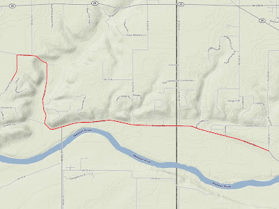
The course was point to point and it was almost entirely into the wind. Heavy riders have a harder time riding uphill than I do. I have a harder time riding into the wind than many others. The reason? Physics. I’m fairly big/tall and I’m kind of lightweight so I have a high surface area to weight ratio. Higher surface area causes more wind resistance. Lower weight (mass) means less momentum one can use to counter this effect. I shouldn’t make excuses, but when it’s related to physics I can hardly resist…

I rode reasonably well, but not as fast as I would have liked. I tied for 19th place. I averaged around 21 mph into the wind, while the winner averaged around 24 mph. Thomas also tied for 19th, and Luke was 13 seconds faster in 15th place.

The General Classification

Since the time gaps between the riders were not that large after the criterium and the road race, the time trial results pretty much determined the final overall stage race results. Here’s how the team did:

Thomas 11th
Luke 12th
Rob 15th
Mark 29th
Karl 39th
Dan 46th

We were not quite as dominant as we were in Hillsboro, but we had a solid race.
The Crosswind

Just as I finished complaining about the ridiculous April headwinds, the leaders of tonight’s ride decided to head mainly East in a strong southerly wind. Spending part of the time on the correct side of the double echelon helped a little, but the rest was pretty brutal. Well April is over, and I can only assume the wind will die down tomorrow. Right?

Speaking of the end of April, I just did a quick tally and my ride mileage was just shy of 600 for the month (down from 831 miles in April 2006). I wonder how much of this I can blame on the horrible winter we’ve had…

Here’s what I’ve been doing this year.

January 2008

Bike Distance # Rides Avg per Ride
Bianchi 83.6 Mile 13 6.43077 Mile
Big Red 3. Mile 1 3. Mile
Dahon 32.6 Mile 6 5.43333 Mile
Thundercougarfalconbird 17.52 Mile 1 17.52 Mile
Total 136.72 Mile 21 6.51048 Mile

February 2008

Bike Distance # Rides Avg per Ride
Bianchi 138.23 Mile 20 6.9115 Mile
Dahon 20.8 Mile 3 6.93333 Mile
Litespeed 16. Mile 1 16. Mile
Thundercougarfalconbird 165.12 Mile 5 33.024 Mile
Total 340.15 Mile 29 11.7293 Mile

March 2008

Bike Distance # Rides Avg per Ride
Bianchi 67.2 Mile 13 5.16923 Mile
Dahon 6.5 Mile 1 6.5 Mile
Thundercougarfalconbird 516.63 Mile 15 34.442 Mile
Total 590.33 Mile 29 20.3562 Mile

April 2008

Bike Distance # Rides Avg per Ride
Bianchi 3.6 Mile 1 3.6 Mile
Big Red 19.14 Mile 2 9.57 Mile
Dahon 51.8 Mile 12 4.31667 Mile
Litespeed 37.1 Mile 1 37.1 Mile
Thundercougarfalconbird 486.26 Mile 13 37.4046 Mile
Total 597.9 Mile 29 20.6172 Mile

January – April 2008

Bike Distance # Rides Avg per Ride
Bianchi 292.63 Mile 47 6.22617 Mile
Big Red 22.14 Mile 3 7.38 Mile
Dahon 111.7 Mile 22 5.07727 Mile
Litespeed 53.1 Mile 2 26.55 Mile
Thundercougarfalconbird 1185.53 Mile 34 34.8685 Mile
Total 1665.1 Mile 108 15.4176 Mile

The Headwind

April in central Illinois is a bitch. Other months are windy, but April is always the worst. This makes for some challenging bike rides.

Clearly it’s very nice when you have a tailwind, but you can’t do an entire ride with the wind at your back if you have any intention of ending up back where you started. The strong crosswinds are just downright dangerous in that there are times that you really think you’re going to be blown right over. You really want to minimize the amount of time you’re in a crosswind like this.

Then there’s the headwind. Oh, the headwind. It’s demoralizing to see a group of 20 strong bicyclists struggling to maintain 13 mph riding directly into a 25 mph (gusting to 40 mph) headwind. Sadly, this has been the situation on the last 10 or so long rides I’ve done this April.

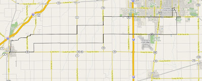
And then there was this weekend. Somehow I (along with two others) showed up at the wrong time for the Saturday ride, so the three of us headed out to Monitcello (50 mile round trip) straight into a powerful west wind. The first few miles seemed to go on for an eternity.

Monticello Ride Map

On Sunday the situation was slightly better in that there were four of us total, but it was slightly worse in that two of those riders were really fast and made the ride even more difficult. I’m not sure how much more I can take.

On the bright side I set a new speed record two weeks ago on the way back from Pesotum when I hit 39.8 mph on flat land. I’ve definitely ridden faster down steep hills, but never on the flat. Amazingly, the guy I was riding with at the time was going over 40 mph and he pulled away from me. Speed records aside, I’m ready for April to end.

The Bike Hole

(Simpsons episode 2F21)

Homer: Hmm. I wonder why he’s so eager to go to the garage?
Moe: The “garage”? Hey fellas, the “garage”! Well, ooh la di da, Mr. French Man.
Homer: Well what do you call it?
Moe: A car hole!

Since watching this episode of the Simpsons (The Springfield Connection) I have frequently referred to our garage as a car hole. It wasn’t until more recently that I realized our car is seriously outnumbered by bikes, and under the circumstances it would be more accurate to call it a bike hole.

Anyway, I spent most of the day Saturday cleaning the bike hole (including unpacking a few boxes that have been sitting in the middle of the floor since we moved in last August).

The Elephant

(Simpsons episode 5F04)

Bart: Wow, I wish I had an elephant!
Lisa: You did, his name was Stampy, you loved him.
Bart: Oh yeah…

Apparently the circus is in town

I rode home from work last night on the same route I ride every night when I noticed an unusual smell near the University of Illinois Assembly Hall. I looked over to my right and there were two elephants being hosed down in the parking lot about 20 meters away from me. That explains the smell. It appears the circus has come to town.

Two elephants in the Assembly Hall parking lot

The Twike

The Twike on the local news

The local news just ran a segment about a local man who drives a Twike, a bike/electric vehicle hybrid. I’ve seen this vehicle several times around town, generally on campus or traveling down Kirby outside my office window.

The Highest Point in Maryland

On my way back from Washington D.C. last weekend I took the opportunity to knock another state off my list of high-points-to-which-I’ve-bicycled. The previous Friday it was Pennsylvania. Monday it was Maryland’s turn. Backbone Mountain, the state’s high point, is nestled in the far western corner of the state, within walking distance from West Virginia.

I spent a good deal of time studying the area with Google Earth on Sunday night in my hotel room. Oakland, Maryland was the clear choice for my starting point. This was only 25 minutes off I-68. The actual peak is not accessible by any road, so I made due with the highest point on the closest road to the peak (U.S. 50), which was conveniently labelled as the Highest Point on the Maryland State Roads System. Perfect.

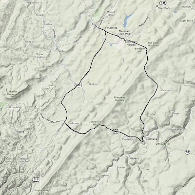
I had a little bit more time for this ride than I did a few days prior in Pennsylvania, so I decided to do a slightly longer ride and make it a loop instead of simply turning around once I reached the top. Since I would be riding down the other side of the mountain, this meant that I would actually have to ride back over the mountain a second time on a different road in order to return to my starting point. The temperature was a chilly 39˚ when I started, so I bundled up.

Backbone Mountain ride map

The unfamiliar roads and dense fog made for some interesting navigation challenges. Like Pennsylvania, there were many rolling hills as I started the loop on U.S. 219. Soon after I turned onto U.S. 50 the road turned upward. The climb itself was shorter than Mt. Davis was a few days prior, but it was much steeper. I spent some quality time in my lowest gear moving along at what seemed like a snail’s pace, but I made it. Six states down (TN, NC, KY, HI, PA, MD), 44 to go.

Rob at the top of Backbone Mountain

Plaque at the top of Backbone Mountain on U.S. 50

I descended the mountain, turned a corner, then started going back up it again, only this time I was on a different road. The second climb seemed roughly the same length and steepness as the first, though it was even foggier. Again I spent much time in my lowest gear. From the top I coasted most of the rest of the way back to Oakland.

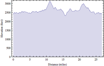
Backbone Mountain ride elevation profile

Once back in town I picked up a 12″ veggie sub on wheat bread with pepper jack cheese, lettuce, onions, tomatoes, pickles, green peppers, & black pepper from Subway. Unfortunately, I didn’t realize until I was driving out of town that the “lemonade” was actually some kind of disgusting carbonated junk instead. I think they must have had some hoses crossed in the fountain machine.

It was a nine hour drive back to Urbana from there. Interestingly, an hour or so later the temperature in West Virginia was around 70˚ and I was actually hot for most of the rest of the trip.

High Point Ride Information
Date: 2008-04-07 9:52 AM EDT
State: Maryland
High Point: Backbone Mountain
Elevation: 3095 feet
Climb Distance: 1.14 miles
Climb Ascent: 469 feet
Climb Average Grade: 7.8%
Climb Maximum Grade: 12%
Ride Distance: 26.8 miles
Ride Total Ascent: 2656 feet
Ride Maximum Speed: 38 miles/hour
Ride Start: Oakland, MD (2372 feet)
Ride End: Oakland, MD (2372 feet)

The Air and Space Museum

(Simpsons episode CABF05)

Warden: Look, he painted a unicorn in outer space. I’m askin’ ya, what’s it breathin’?
Homer: Air?
Warden: Ain’t no air in space!
Homer: There’s an air n’ space museum.

When I was younger I wanted to be a pilot and astronaut. This wasn’t just my answer to the question of “What do you want to be when you grow up, little boy?” I really wanted to be a pilot and astronaut. Every Monday night my dad & I would watch Wings, a show on Discovery channel that each week chronicled a different type of aircraft. I watched them all. I spent hours reading encyclopedias (remember those reference books that existed before the internet) about every single NASA space mission that had taken place. I had it all memorized. I hoped that one day I too would have the right stuff. My career ambitions may have changed over the years, but my fascination with flight and space flight remain. Needless to say, the National Air and Space Museum provided me with hours and hours of (free) enjoyment.

I woke up late last Sunday morning in D.C. after getting to bed late following the ASP reunion. I was planning to leave D.C. early that afternoon so I didn’t intend to spend much time at the museum, maybe an hour or two. Melissa & I toured the museum extensively when we were there in 2003, so I figured there probably wasn’t as much to see the second time around. I was wrong. My hour or two trip ballooned into four or five hours once I was within the museum’s walls. I covered every inch of the museum, aside from the National Treasures exhibit which inexplicably had a one hour wait.

There were many oldies but goodies. As soon as you walk in the door you are greeted by the Apollo 11 command module. The first humans to walk on the moon used this spacecraft to return to earth. Hanging just above that is the Sprit of St. Louis, the first aircraft to fly non-stop across the atlantic ocean.

Apollo 11 Command Module

Sprit of St. Louis

There were some new items added to the museum in the past five years. They added a test unit of one of the recent Mars rovers. Two similar rovers landed on mars in 2004 and are still performing experiments to this day. They also added SpaceShipOne, the first privately funded civilian spacecraft to carry a human into space (also in 2004).

Mars rover

SpaceShipOne

Then there were the interesting artifacts I new a lot about in the past, but had completely forgotten. Among them were the Apollo-Soyuz Test Project, a joint USA/USSR space mission in the 1970’s where astronauts & cosmonauts docked their spacecrafts together (and presumably had some kind of party). Then there was Skylab, the first attempt at a space station by the USA (also in the 1970’s) that fell back to earth (nobody was aboard at the time) and crashed in Australia. Whoops.

Apollo-Soyuz Test Project (right), Hubble telescope (backup unit, on left)

Skylab (backup unit, covered in gold foil)

Finally, something particularly interesting to me is the Gossamer Condor. This is a 70 pound bicycle with wings that was the first human powered machine to sustain flight. A similar machine to this crossed the English channel a few years later. I have a decent power to weight ratio, I could totally fly that thing :)

Gossamer Condor

So I stayed quite a bit longer than I intended. It was no problem. I returned to my quarters then departed D.C. late in the afternoon. My next stop was western Maryland, where a certain mountain awaited my arrival.

The Highest Point in Pennsylvania

It’s not widely known outside of this household that I have a goal to bicycle to the highest point in all 50 states. Well, at least the highest point that is accessible via bicycle, generally on a paved road. It is a lofty goal indeed, but I’m not super strict about the rules… and I’m not in any huge hurry. I just like riding.

As of last week I had 4 states down, including some big ones (Tennessee, North Carolina, Kentucky, & Hawaii). When I was planning my trip to Washington D.C. this past weekend I took a quick glance at some web sites and saw that Pennsylvania & Maryland had high points that were not very far out of my way (additionally West Virginia, Ohio, & Indiana, but I thought two would suffice for a single weekend). So I took my bike and thought if I had time I would ride them, if not no big deal.

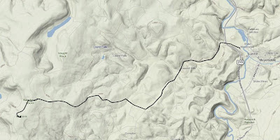
The route from Meyersdale to the summit of Mt. Davis

I drove for nine or so hours by the time I reached Meyersdale, PA, at the foot of Mt. Davis. The weather was nice, and I was sick of driving, so I rode. As I was coming into town I noticed there were many wind generators perched atop the rolling hills. As soon as I stepped out of the car I realized why. It was windy. Really windy. And unfortunately, it was going to be a headwind the entire way up Mt. Davis.

Wind generators near Meyersdale, PA

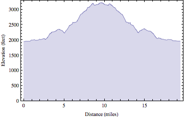
The elevation of Meyersdale was 1935 ft. and the summit of Mt. Davis is 3213-ish ft. So it was a decent change in elevation, but it was no Mauna Kea. As I began the 10 mile ride to the summit I quickly realized this climb was going to be a little different than many of the previous mountains I have ridden. It was really just one large rolling hill after another. It wasn’t very steep (the average grade was 3.2%, with one short 13% section). There were no switchbacks. The strong headwind made it tough, and I didn’t have the best legs after nine hours of driving, so it was slow going.

A sign directing visitors to Mt. Davis with rolling hills in the background

I rode through lots of farmland and passed many people I assume were Amish. There were several horse drawn buggies and a few diesel powered tractors (diesel is apparently okay for the Amish). Everyone waved and seemed rather friendly.

Towards the top the landscape finally turned from large rolling hills into a real actual climb. It got a little steeper at this point, but it was still managable. There was a picnic area at the summit, a sign indicating the significance of the location, and a short distance away was an observation tower. The wind made walking up the tower stairs an interesting experience, but I survived.

Rob at the summit of Mt. Davis, PA

View of Meyersdale, PA from observation tower at summit of Mt. Davis

Mt. Davis ride elevation profile

The long, straight roads and strong tailwind allowed for some fast descending. At one point I passed a group of Amish children who all waved to me as I sped past at 35 mph. When I returned to Meyersdale, I packed up my bike, got back in the car, and drove the remaining three hours to D.C. It was a good way to break up the monotony of driving such a long distance in one day.

High Point Ride Information
Date: 2008-04-04 3:19 PM EDT
State: Pennsylvania
High Point: Mt. Davis
Elevation: 3213 feet
Climb Distance: 3.5 miles
Climb Ascent: 1010 feet
Climb Average Grade: 5.4%
Climb Maximum Grade: 13%
Ride Distance: 19.4 miles
Ride Total Ascent: 1973 feet
Ride Maximum Speed: 45.7 miles/hour
Ride Start: Meyersdale, PA (1935 feet)
Ride End: Meyersdale, PA (1935 feet)